
Bangued地形图
点击地图以显示海拔。
Bangued
According to the Philippine Statistics Authority, the municipality has a land area of 105.70 square kilometres (40.81 sq mi) constituting 2.54% of the 4,165.25-square-kilometre- (1,608.21 sq mi) total area of Abra. The town is generally mountainous from north to south; however, it is flat and rolling at the midsection. From here it has an elevation of 30 metres (98 ft) above mean sea level. In the north, which consists mostly of mountains, elevation ranges from 60 to 1,036 metres (197 to 3,399 ft). In the south, which is interspersed with mountain and hills, elevation ranges from 45 to 300 metres (148 to 984 ft). One such hill is Cassamata Hill which was declared a national park.
关于这张地图
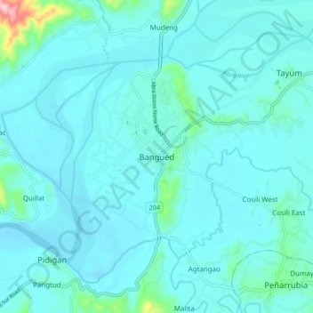
名称:Bangued地形图、海拔、地势。
平均海拔:51 米
最低海拔:24 米
最高海拔:298 米
其他地形图
点击地图以查看其地形、其海拔和其地势。