
Hirta地形图
点击地图以显示海拔。
关于这张地图
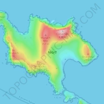
名称:Hirta地形图、海拔、地势。
地点:Hirta, Western Isles, Scotland, United Kingdom (57.79876 -8.61772 57.82838 -8.54960)
平均海拔:58 米
最低海拔:-5 米
最高海拔:425 米
其他地形图
点击地图以查看其地形、其海拔和其地势。
North Rona
United Kingdom > Scotland > Western Isles
Rona (Scottish Gaelic: Rònaigh) is an uninhabited Scottish island in the North Atlantic. It is often referred to as North Rona to distinguish it from the island of South Rona in the Inner Hebrides. It has an area of 109 hectares (270 acres) and a maximum elevation of 108 metres (354 ft).
平均海拔:4 米