
South Hamilton地形图
点击地图以显示海拔。
关于这张地图
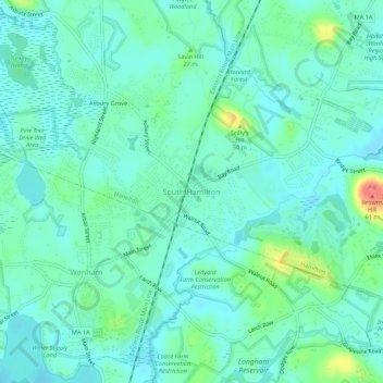
名称:South Hamilton地形图、海拔、地势。
平均海拔:19 米
最低海拔:5 米
最高海拔:67 米
其他地形图
点击地图以查看其地形、其海拔和其地势。
Danvers
United States > Massachusetts > Essex County
Though being at sea level in the Danversport area, the town has numerous hills reaching around 130 to 180 feet in elevation, including Dales Hill (located at St. John's Preparatory School), Ferncroft Hill, Folly Hill, Hathorne Hill, Lindall Hill, Nichols Hill, Putnam Hill, Rocky Hill and Whipple Hill (part of…
平均海拔:23 米
Boxford
United States > Massachusetts > Essex County
Boxford is divided into Boxford Village (commonly called East Boxford) and West Boxford Village, corresponding to the respective East and West Boxford centers. It is heavily forested and criss-crossed by various streams and brooks, many of which empty into the Ipswich River on Boxford's southern border. A…
平均海拔:35 米
Haverhill
United States > Massachusetts > Essex County
According to the United States Census Bureau, the city has a total area of 35.6 square miles (92.3 km2), of which 33.0 square miles (85.4 km2) is land and 2.7 square miles (6.9 km2), or 7.47%, is water. The city ranks 60th in the Commonwealth in terms of land area, and is the largest city or town in Essex…
平均海拔:39 米
Topsfield
United States > Massachusetts > Essex County
According to the United States Census Bureau, Topsfield has a total area of 12.8 square miles (33.2 km2), of which 11.9 square miles (30.9 km2) are land and 0.89 square miles (2.3 km2), or 7.00%, is water. Topsfield lies in the geographic center of Essex County, Massachusetts. Like its namesake in Essex,…
平均海拔:25 米
Amesbury
United States > Massachusetts > Essex County
Amesbury is located at 42°51′29″N 70°55′50″W / 42.85806°N 70.93056°W / 42.85806; -70.93056. According to the United States Census Bureau, the city has a total area of 13.7 square miles (35.5 km2), of which 12.3 square miles (31.8 km2) is land and 1.5 square miles (3.8 km2), or 10.65%, is…
平均海拔:25 米
Topsfield
United States > Massachusetts > Essex County
According to the United States Census Bureau, Topsfield has a total area of 12.8 square miles (33.2 km2), of which 11.9 square miles (30.9 km2) are land and 0.89 square miles (2.3 km2), or 7.00%, is water. Topsfield lies in the geographic center of Essex County, Massachusetts. Like its namesake in Essex,…
平均海拔:25 米
Haverhill
United States > Massachusetts > Essex County
According to the United States Census Bureau, the city has a total area of 35.6 square miles (92.3 km2), of which 33.0 square miles (85.4 km2) is land and 2.7 square miles (6.9 km2), or 7.47%, is water. The city ranks 60th in the Commonwealth in terms of land area, and is the largest city or town in Essex…
平均海拔:39 米
Topsfield
United States > Massachusetts > Essex County
According to the United States Census Bureau, Topsfield has a total area of 12.8 square miles (33.2 km2), of which 11.9 square miles (30.9 km2) are land and 0.89 square miles (2.3 km2), or 7.00%, is water. Topsfield lies in the geographic center of Essex County, Massachusetts. Like its namesake in Essex,…
平均海拔:24 米
Hamilton
United States > Massachusetts > Essex County
According to the United States Census Bureau, the town has a total area of 14.9 square miles (38.6 km2), of which 14.2 square miles (36.7 km2) is land and 0.73 square miles (1.9 km2), or 4.89%, is water. Hamilton lies 5 miles (8 km) inland from Massachusetts Bay, and both the eastern and western portion of…
平均海拔:19 米
Boxford
United States > Massachusetts > Essex County
Boxford is divided into Boxford Village (commonly called East Boxford) and West Boxford Village, corresponding to the respective East and West Boxford centers. It is heavily forested and criss-crossed by various streams and brooks, many of which empty into the Ipswich River on Boxford's southern border. A…
平均海拔:35 米
Danvers
United States > Massachusetts > Essex County
Though being at sea level in the Danversport area, the town has numerous hills reaching around 130 to 180 feet in elevation, including Dales Hill (located at St. John's Preparatory School), Ferncroft Hill, Folly Hill, Hathorne Hill, Lindall Hill, Nichols Hill, Putnam Hill, Rocky Hill and Whipple Hill (part of…
平均海拔:22 米
Haverhill
United States > Massachusetts > Essex County
According to the United States Census Bureau, the city has a total area of 35.6 square miles (92.3 km2), of which 33.0 square miles (85.4 km2) is land and 2.7 square miles (6.9 km2), or 7.47%, is water. The city ranks 60th in the Commonwealth in terms of land area, and is the largest city or town in Essex…
平均海拔:39 米