
Longformacus地形图
点击地图以显示海拔。
关于这张地图
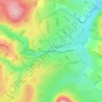
名称:Longformacus地形图、海拔、地势。
平均海拔:242 米
最低海拔:169 米
最高海拔:364 米
其他地形图
点击地图以查看其地形、其海拔和其地势。
Moffat Hills
United Kingdom > Scotland > Scottish Borders > Tweedsmuir
The Megget Stane (OS. Ref. NT152203) is by a cattle grid at the highest point between the Talla and Megget reservoirs on the minor road which runs from Tweedsmuir on the A701 to Cappercleuch by shore of St Mary's Loch. It is quite easy to miss the stone when coming from Talla as it is hidden by a gate. At an…
平均海拔:430 米