
Stavelot地形图
点击地图以显示海拔。
Stavelot
Stavelot has an oceanic climate influenced by its high elevation and inland position towards a more continental type by Belgian standards. Being located at a lower elevation than neighbouring village Malmedy at the other end of the original layout of the Spa-Francorchamps race track, Stavelot is slightly milder, drier and sunnier than Malmedy year round.
关于这张地图
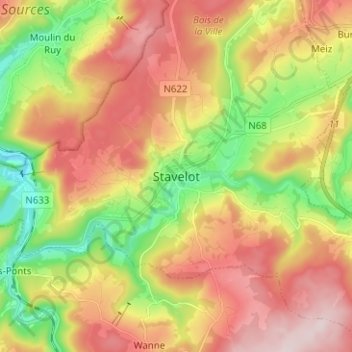
名称:Stavelot地形图、海拔、地势。
地点:Stavelot, Verviers, Liège, Wallonia, 4970, Belgium (50.35424 5.89103 50.43424 5.97103)
平均海拔:401 米
最低海拔:219 米
最高海拔:585 米
其他地形图
点击地图以查看其地形、其海拔和其地势。