
Mount Disappointment地形图
点击地图以显示海拔。
关于这张地图
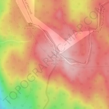
名称:Mount Disappointment地形图、海拔、地势。
平均海拔:706 米
最低海拔:513 米
最高海拔:793 米
其他地形图
点击地图以查看其地形、其海拔和其地势。
Collingwood
Australia > Victoria > Melbourne
Collingwood's topography is mostly flat, but a prominent slope extends from Hoddle Street up to Smith Street, and also along sections of Hoddle Street.
平均海拔:30 米
St Andrews Beach
Australia > Victoria > Melbourne
St Andrews Beach features a unique topography known as The Cups Country, which creates the ideal environment for golf courses. Golfers have a choice of several nearby golf courses including the St Andrews Beach Club on Sandy Road, Moonah Links off Truemans Road, and The Dunes on Browns Road.
平均海拔:10 米