
Mount Hubbard地形图
点击地图以显示海拔。
关于这张地图
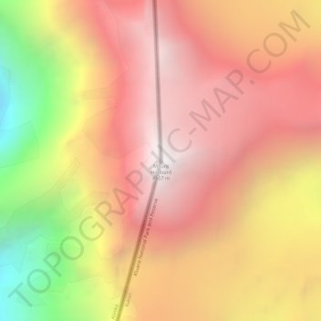
名称:Mount Hubbard地形图、海拔、地势。
地点:Mount Hubbard, Yakutat, Alaska, United States (60.31938 -139.07218 60.31948 -139.07208)
平均海拔:3,861 米
最低海拔:2,692 米
最高海拔:4,573 米
其他地形图
点击地图以查看其地形、其海拔和其地势。
Hubbard Glacier
United States > Alaska > Yakutat
The longest source for Hubbard Glacier originates 122 kilometres (76 mi) from its snout and is located at about 61°00′N 140°09′W / 61.000°N 140.150°W / 61.000; -140.150, approximately 8 kilometres (5 mi) west of Mount Walsh with an elevation around 3,400 metres (11,200 ft). A shorter tributary…
平均海拔:1,892 米
Malaspina Glacier
United States > Alaska > Yakutat
The Malaspina is up to 600 meters (2,000 ft) thick in places, with the elevation of its bottom being estimated to be as much as 300 m (980 ft) below sea level. There are two lakes on its margins: Oily Lake to the northwest, at the foot of the Samovar Hills between the Agassiz and Seward glaciers, and Malaspina…
平均海拔:393 米