Villaretto地形图
点击地图以显示海拔。
关于这张地图
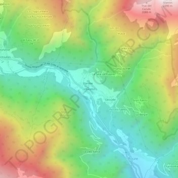
名称:Villaretto地形图、海拔、地势。
地点:Villaretto, Roure, Torino, Piemonte, Italia (44.99704 7.09547 45.03704 7.13547)
平均海拔:1,350 米
最低海拔:839 米
最高海拔:2,186 米
其他地形图
点击地图以查看其地形、其海拔和其地势。

点击地图以显示海拔。
名称:Villaretto地形图、海拔、地势。
地点:Villaretto, Roure, Torino, Piemonte, Italia (44.99704 7.09547 45.03704 7.13547)
平均海拔:1,350 米
最低海拔:839 米
最高海拔:2,186 米
点击地图以查看其地形、其海拔和其地势。