点击地图以显示海拔。
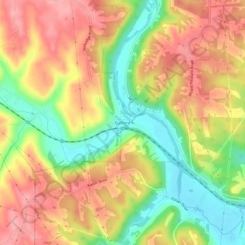
名称:Guilford地形图、海拔、地势。
地点:Guilford, York Township, Dearborn County, Indiana, United States (39.14811 -84.93190 39.18811 -84.89190)
平均海拔:209 米
最低海拔:143 米
最高海拔:263 米
点击地图以查看其地形、其海拔和其地势。
United States > Indiana > Dearborn County
平均海拔:233 米
平均海拔:186 米
平均海拔:177 米
平均海拔:222 米
平均海拔:168 米
平均海拔:224 米
平均海拔:299 米
United States > Indiana > Dearborn County > Greendale