
Aston地形图
点击地图以显示海拔。
关于这张地图
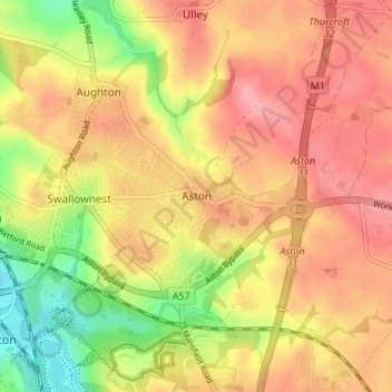
名称:Aston地形图、海拔、地势。
平均海拔:89 米
最低海拔:32 米
最高海拔:127 米
其他地形图
点击地图以查看其地形、其海拔和其地势。
Woodsetts
United Kingdom > England > Rotherham
Woodsetts is a village and civil parish in the Metropolitan Borough of Rotherham in South Yorkshire, England, on the border with Nottinghamshire. It lies between the towns of Dinnington and Worksop at an elevation of around 60 metres above sea level, and has a population of 1,746 at the 2011 Census. The…
平均海拔:70 米
Thorpe Salvin
United Kingdom > England > Rotherham
Thorpe Salvin is a village and a civil parish in the Metropolitan Borough of Rotherham in South Yorkshire, England, on the border with Nottinghamshire. It lies between Worksop and Harthill, and is located at an elevation of around 110 metres above sea level. At the 2011 Census, it had a population of 476, down…
平均海拔:102 米
Hellaby
United Kingdom > England > Rotherham
With a Dutch impression that was influenced by the style common in the colonies, the Hall was built on a hill and hence an extra storey was required to obtain the height at the front elevation.
平均海拔:113 米