Groveland地形图
点击地图以显示海拔。
关于这张地图
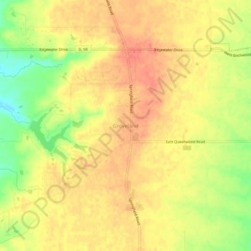
名称:Groveland地形图、海拔、地势。
地点:Groveland, Tazewell County, Illinois, 61535, United States (40.57254 -89.55454 40.61254 -89.51454)
平均海拔:227 米
最低海拔:194 米
最高海拔:243 米
其他地形图
点击地图以查看其地形、其海拔和其地势。

点击地图以显示海拔。
名称:Groveland地形图、海拔、地势。
地点:Groveland, Tazewell County, Illinois, 61535, United States (40.57254 -89.55454 40.61254 -89.51454)
平均海拔:227 米
最低海拔:194 米
最高海拔:243 米
点击地图以查看其地形、其海拔和其地势。