
Papeete地形图
点击地图以显示海拔。
Papeete
Previously, during the construction of the Faʻaiere water tower with a capacity of 150,000 litres for the drinking water supply of the city of Papeʻetē, a difference in altitude of 37 metres (121 ft) was overcome with a light railway laid on a 220 metres (720 ft) long inclined plane. A winch driven by a 12-horsepower Fowler or Decauville locomobile carried three narrow gauge railway trucks at a time, consuming up to 200 kilograms (440 lb) of coal per day for about sixty journeys. Paul Decauville mentioned in a letter to Governor Theodore Lacascade, dated 18 June 1891, an order for "15 kilometres (9.3 mi) of 600 mm (1 ft 11+5⁄8 in) portable rail tracks and about 12,000 francs of rolling stock, payable in three years", presumably for a tramway from Papeʻetē to Punaʻauia operated by hand or animals.
关于这张地图
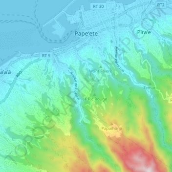
名称:Papeete地形图、海拔、地势。
平均海拔:224 米
最低海拔:-2 米
最高海拔:1,133 米
其他地形图
点击地图以查看其地形、其海拔和其地势。
Mont Orohena
France > French Polynesia > Windward Islands > Māhina
Mont Orohena is a mountain located in the South Pacific, on the island of Tahiti. With an elevation of 2,241 metres (7,352 ft) above sea level, it is the highest point of French Polynesia. Mont Orohena is an extinct volcano and ranks 7th in the world for topographic isolation.
平均海拔:1,282 米
Fatu Huku
France > French Polynesia > Marquesas Islands > Hiva Oa
The island is essentially a huge rock, looming steep-sided out of the ocean and rising to a flattened plateau with a maximum elevation of 361 metres (1,184 ft). Fatu Huku is the youngest of the volcanic Marquesas Islands, estimated to be only 1.3 million years old which accounts, in part, for its ruggedness as…
平均海拔:8 米