Oubourcy地形图
点击地图以显示海拔。
关于这张地图
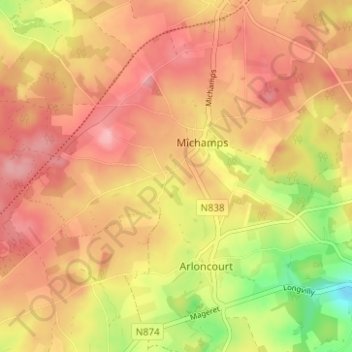
名称:Oubourcy地形图、海拔、地势。
地点:Oubourcy, Longvilly, Bastogne, Luxembourg, Wallonie, Belgique (50.01788 5.77918 50.05788 5.81918)
平均海拔:504 米
最低海拔:425 米
最高海拔:550 米

点击地图以显示海拔。
名称:Oubourcy地形图、海拔、地势。
地点:Oubourcy, Longvilly, Bastogne, Luxembourg, Wallonie, Belgique (50.01788 5.77918 50.05788 5.81918)
平均海拔:504 米
最低海拔:425 米
最高海拔:550 米