
Gonzaga地形图
点击地图以显示海拔。
Gonzaga
It has a total land area of 56,743 hectares (140,220 acres), the majority of which remains undeveloped. It has large stretches of virgin forests, especially throughout the mountainous areas of the Sierra Madre mountain range. The highest elevation in the municipality is 1,130 metres (3,710 ft) above sea level, located at Mount Cagua in Barangay Magrafil.
关于这张地图
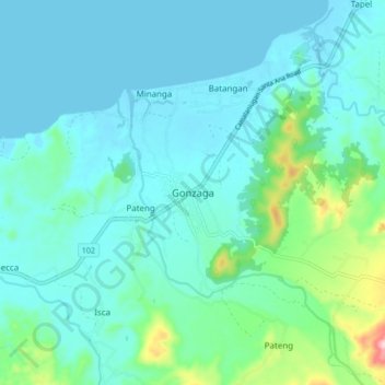
名称:Gonzaga地形图、海拔、地势。
地点:Gonzaga, Cagayan, Cagayan Valley, 3513, Philippines (18.22120 121.95665 18.30120 122.03665)
平均海拔:38 米
最低海拔:-1 米
最高海拔:237 米
其他地形图
点击地图以查看其地形、其海拔和其地势。