
Bald Eagle地形图
点击地图以显示海拔。
关于这张地图
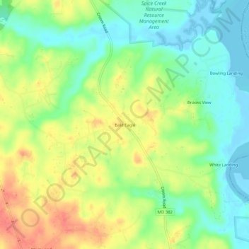
名称:Bald Eagle地形图、海拔、地势。
地点:Bald Eagle, Prince George's County, Maryland, United States (38.65651 -76.74247 38.69651 -76.70247)
平均海拔:28 米
最低海拔:-4 米
最高海拔:65 米
其他地形图
点击地图以查看其地形、其海拔和其地势。
College Park
United States > Maryland > Prince George's County
College Park features a relatively flat terrain typical of the Atlantic Coastal Plain, with an average elevation of around 100 feet above sea level. The landscape is characterized by gently rolling hills, particularly in the northern and western parts, while lower-lying areas can be found near the various…
平均海拔:38 米
Accokeek
United States > Maryland > Prince George's County > Accokeek
According to the United States Census Bureau, the place has a total area of 28.803 square miles (74.60 km2), of which 27.436 square miles (71.06 km2) is land and 1.367 square miles (3.54 km2) is water. Accokeek has an average elevation of 194 feet (59 m).
平均海拔:46 米
College Park
United States > Maryland > Prince George's County
The Lakeland neighborhood was developed beginning in 1890 around the Baltimore and Ohio Railroad, whose Branchville and Calvert Road depots were located approximately one mile to the north and south, respectively. Lakeland was created by Edwin Newman, who improved the original 238 acres (0.96 km2) located to…
平均海拔:38 米
Hyattsville
United States > Maryland > Prince George's County
Downtown Hyattsville underwent revitalization in the early 2000s with the development of Arts District Hyattsville, part of the Gateway Arts District, a private project which includes townhomes, live-work units, and retail space. The master developer of the 25-acre neighborhood was Bethesda-based EYA, and was…
平均海拔:24 米
Seabrook
United States > Maryland > Prince George's County > Glenn Dale
Seabrook takes its name from Thomas Seabrook, who was a topographical engineer with the Pennsylvania Railroad. He originally built three cottages and a park with fenced-in tame deer in the area near the rail station[5] in the early 1870s.
平均海拔:49 米