
Cane Hill Mountain地形图
点击地图以显示海拔。
关于这张地图
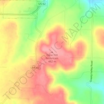
名称:Cane Hill Mountain地形图、海拔、地势。
平均海拔:443 米
最低海拔:382 米
最高海拔:486 米
其他地形图
点击地图以查看其地形、其海拔和其地势。
Fayetteville
United States > Arkansas > Washington County
Fayetteville is nestled in the picturesque Ozark Mountains, characterized by rolling hills, lush forests, and scenic valleys that define the region's topography. The elevation in Fayetteville ranges from about 1,100 feet to over 1,500 feet above sea level, creating a varied landscape that features steep ridges…
平均海拔:401 米
Greenland
United States > Arkansas > Washington County
The climate in this area is characterized by hot, extremely humid summers and generally cool to very cold winters depending on elevation. According to the Köppen Climate Classification system, Greenland has a humid subtropical climate, abbreviated "Cfa" on climate maps.
平均海拔:419 米
Fayetteville
United States > Arkansas > Washington County
...yet I venture the assertion that nowhere in said country—or for that matter, in any part of the state—could be found a lovelier elevation, or a lovelier grove of graceful oaks, or a more commanding view, or, in fine, a spot better suited and adapted for the purposes designated than the one chosen for…
平均海拔:401 米
West Fork
United States > Arkansas > Washington County
West Fork is located at 35°56′08″N 94°10′48″W / 35.93556°N 94.18000°W / 35.93556; -94.18000 (35.9356771, -94.1801038) at an elevation of 1,358 feet (414 m). According to the United States Census Bureau, the city has a total area of 3.3 square miles (8.5 km2), all land.
平均海拔:468 米