
Nabua地形图
点击地图以显示海拔。
Nabua
Nabua has about 8,803.0600 hectares or 99.42% very low elevation or less than 100 meters elevation and remaining 51.3593 hectares or 0.58% of low elevation or between 100 and 300 meters elevation. Its slope covers about 7,927.3616 hectares or 89.53% which are level to nearly level (0-3%) while the remaining 927.0577 hectares or 10.47% are rolling to moderately steep (18-30%)
关于这张地图
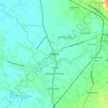
名称:Nabua地形图、海拔、地势。
地点:Nabua, Camarines Sur, Bicol Region, 4434, Philippines (13.36752 123.33306 13.44752 123.41306)
平均海拔:14 米
最低海拔:2 米
最高海拔:64 米
其他地形图
点击地图以查看其地形、其海拔和其地势。