
Salopha地形图
点击地图以显示海拔。
关于这张地图
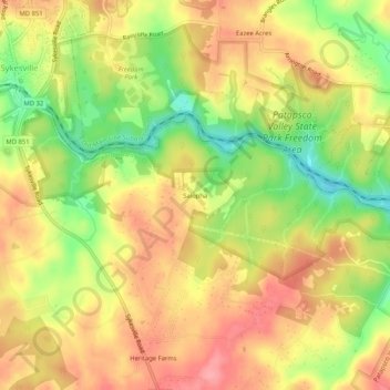
名称:Salopha地形图、海拔、地势。
地点:Salopha, Howard County, Maryland, 21784, United States (39.33288 -76.96553 39.37288 -76.92553)
平均海拔:146 米
最低海拔:90 米
最高海拔:187 米
其他地形图
点击地图以查看其地形、其海拔和其地势。
Columbia
United States > Maryland > Howard County > Columbia
The primary landforms in Columbia are rolling hills and stream valleys; Columbia's road network is laid out to follow the terrain, with many winding streets and cul-de-sacs. Elevations range from about 200 to 500 feet (61 to 152 m) above sea level. Most of Columbia is drained by the Middle Patuxent and Little…
平均海拔:114 米
Columbia
United States > Maryland > Howard County > Columbia
The primary landforms in Columbia are rolling hills and stream valleys; Columbia's road network is laid out to follow the terrain, with many winding streets and cul-de-sacs. Elevations range from about 200 to 500 feet (61 to 152 m) above sea level. Most of Columbia is drained by the Middle Patuxent and Little…
平均海拔:113 米