
Beulah地形图
点击地图以显示海拔。
关于这张地图
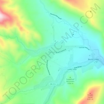
名称:Beulah地形图、海拔、地势。
地点:Beulah, Pueblo County, Colorado, 81023, United States (38.05501 -105.00666 38.09501 -104.96666)
平均海拔:2,013 米
最低海拔:1,877 米
最高海拔:2,326 米
其他地形图
点击地图以查看其地形、其海拔和其地势。
Pueblo
United States > Colorado > Pueblo County
Pueblo has a steppe climate (Köppen BSk), with four distinct seasons. Winter days are usually mild, but the high does not surpass freezing on an average 15.3 days per year, and lows fall to 0 °F (−18 °C) or below on 7.8 nights. Snowfall usually falls in light amounts, and due to the high altitude, and the…
平均海拔:1,487 米
Rye
United States > Colorado > Pueblo County
Rye has a subtropical highland climate (Köppen Cfb), a climate type usually associated with maritime regions, but is also found in high elevation areas in which summer temperatures are moderated by altitude. Precipitation exceeds that of semi-arid places, and average winter temperatures exceed freezing (O°C,…
平均海拔:2,090 米
Pueblo
United States > Colorado > Pueblo County
Pueblo has a steppe climate (Köppen BSk), with four distinct seasons. Winter days are usually mild, but the high does not surpass freezing on an average 15.3 days per year, and lows fall to 0 °F (−18 °C) or below on 7.8 nights.[32] Snowfall usually falls in light amounts, and due to the high altitude, and…
平均海拔:1,487 米