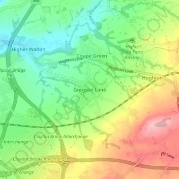
点击地图以显示海拔。
名称:Gregson Lane地形图、海拔、地势。
地点:Gregson Lane, South Ribble, Lancashire, England, PR5 0DP, United Kingdom (53.71408 -2.64017 53.75408 -2.60017)
平均海拔:69 米
最低海拔:11 米
最高海拔:157 米
点击地图以查看其地形、其海拔和其地势。
United Kingdom > England > Lancashire > South Ribble > Leyland
平均海拔:45 米
United Kingdom > England > Lancashire > South Ribble
平均海拔:58 米
United Kingdom > England > Lancashire > South Ribble > Longton
平均海拔:15 米
United Kingdom > England > Lancashire > South Ribble > Penwortham
平均海拔:23 米
平均海拔:35 米