
Belfair地形图
点击地图以显示海拔。
关于这张地图
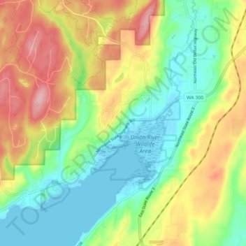
名称:Belfair地形图、海拔、地势。
地点:Belfair, Mason County, Washington, United States (47.41664 -122.88748 47.47625 -122.80076)
平均海拔:65 米
最低海拔:-2 米
最高海拔:162 米
其他地形图
点击地图以查看其地形、其海拔和其地势。
Mount Ellinor
United States > Washington > Mason County
Mount Ellinor is a peak in the Olympic Mountains of Washington, United States. It is located in an area designated as the Mount Skokomish Wilderness. The mountain is a popular day hike in the summer months; the summit is reachable via a steep-but-brief 3.3-mile (5.3 km) trail which gains about 3,200 feet (980…
平均海拔:1,334 米