
Lawrence地形图
点击地图以显示海拔。
Lawrence
Downtown Lawrence is located at 38°58′18″N 95°14′7″W / 38.97167°N 95.23528°W / 38.97167; -95.23528 (38.959902, −95.253199), approximately 25 miles (40 kilometers) east of Topeka, and 35 mi (56 km) west of Kansas City, Kansas. Though Lawrence has a designated elevation of 866 feet (264 m), the highest elevation is Mount Oread on the University of Kansas campus with an elevation of 1,020 feet (310 m).
关于这张地图
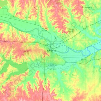
名称:Lawrence地形图、海拔、地势。
地点:Lawrence, Douglas County, Kansas, 66044, United States (38.81194 -95.39595 39.13194 -95.07595)
平均海拔:283 米
最低海拔:237 米
最高海拔:353 米
其他地形图
点击地图以查看其地形、其海拔和其地势。