
Bishop地形图
点击地图以显示海拔。
关于这张地图
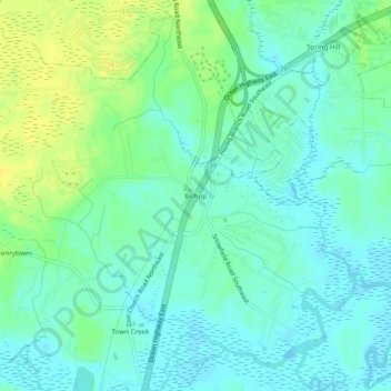
名称:Bishop地形图、海拔、地势。
地点:Bishop, Brunswick County, North Carolina, United States (34.15906 -78.10499 34.19906 -78.06499)
平均海拔:8 米
最低海拔:-1 米
最高海拔:22 米
其他地形图
点击地图以查看其地形、其海拔和其地势。
Ocean Isle Beach
United States > North Carolina > Brunswick County
Ocean Isle Beach is a picturesque barrier island characterized by its low-lying terrain and sandy shorelines. The topography features an average elevation of about 3 feet (1 meter) above sea level, with the landscape gently sloping towards the Atlantic Ocean. The island spans approximately 7 miles in length…
平均海拔:4 米
Bald Head Island
United States > North Carolina > Brunswick County
Located at the tip of Cape Fear and residing at the convergence of the Cape Fear River and Atlantic Gulf Stream, the land mass of Bald Head Island ends, trailing off into 30 miles (48 km) of treacherous sand bars known as Frying Pan Shoals. In this area, large sand bars seasonally emerge from and subsequently…
平均海拔:0 米
Caswell Beach
United States > North Carolina > Brunswick County
Roughly halfway distant from Wilmington, North Carolina and Myrtle Beach, South Carolina, Caswell Beach is located on the east end of Oak Island. This island is the easternmost of the South Brunswick Islands which were formed in the late 1930s by the construction of the Intracoastal Waterway (ICW) which was…
平均海拔:1 米