Connersville地形图
点击地图以显示海拔。
关于这张地图
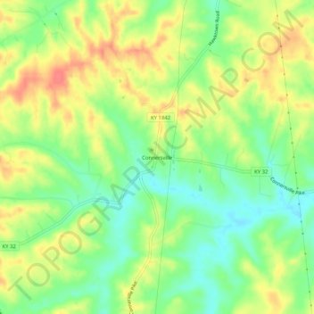
名称:Connersville地形图、海拔、地势。
地点:Connersville, Harrison County, Kentucky, United States (38.36007 -84.43272 38.40007 -84.39272)
平均海拔:256 米
最低海拔:228 米
最高海拔:285 米
其他地形图
点击地图以查看其地形、其海拔和其地势。

点击地图以显示海拔。
名称:Connersville地形图、海拔、地势。
地点:Connersville, Harrison County, Kentucky, United States (38.36007 -84.43272 38.40007 -84.39272)
平均海拔:256 米
最低海拔:228 米
最高海拔:285 米
点击地图以查看其地形、其海拔和其地势。