
Marlingford地形图
点击地图以显示海拔。
关于这张地图
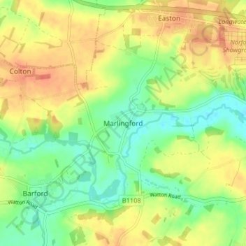
名称:Marlingford地形图、海拔、地势。
平均海拔:34 米
最低海拔:11 米
最高海拔:56 米
其他地形图
点击地图以查看其地形、其海拔和其地势。
Wymondham
United Kingdom > England > Norfolk > South Norfolk
Wymondham's topography is marked by its river meadow and flat, low-lying agricultural landscape, much like the rest of East Anglia. The parish has an area of 17.11 square miles (44.31 km2). The geology is based on chalk, with a layer of boulder clay laid down in the last ice age. The River Tiffey, flowing…
平均海拔:43 米
Ashby St. Mary
United Kingdom > England > Norfolk > South Norfolk
Ashby's topography is, like most of East Anglia, made up of river meadows and flat agricultural landscape. The geology mostly consists of Cainozoic Sedimentary rock, with a layer of boulder clay and sand laid down in the last ice age. Ashby St Mary has slightly acidic loamy and clayey soils with impeded…
平均海拔:20 米