
Mount Patrick地形图
点击地图以显示海拔。
关于这张地图
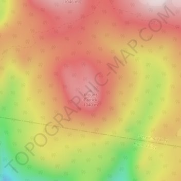
名称:Mount Patrick地形图、海拔、地势。
地点:Mount Patrick, Derwent Valley, Tasmania, Australia (-42.89750 147.07993 -42.89740 147.08003)
平均海拔:863 米
最低海拔:505 米
最高海拔:1,083 米
其他地形图
点击地图以查看其地形、其海拔和其地势。
Launceston
Launceston is at 41°26′31″S 147°8′42″E / 41.44194°S 147.14500°E / -41.44194; 147.14500 in the Tamar Valley, Northern Tasmania. The valley was formed by volcanic and glacial forces over 10 million years ago. The city is about 45 kilometres (28 mi) south of the Bass Strait, with its closest…
平均海拔:194 米
Launceston
Launceston is at 41°26′31″S 147°8′42″E / 41.44194°S 147.14500°E / -41.44194; 147.14500 in the Tamar Valley, Northern Tasmania. The valley was formed by volcanic and glacial forces over 10 million years ago. The city is about 45 kilometres (28 mi) south of the Bass Strait, with its closest…
平均海拔:26 米