
Stone Mountain地形图
点击地图以显示海拔。
Stone Mountain
The park is owned by the state of Georgia and is currently managed by Herschend Family Entertainment. At its summit, the elevation is 1,686 feet (514 m) above sea level and 825 feet (251 m) above the surrounding area. Stone Mountain is well known for not only its geology, but also the enormous rock relief on its north face, the largest bas-relief artwork in the world. The carving, completed in 1972, depicts three Confederate leaders, Jefferson Davis, Robert E. Lee, and Stonewall Jackson.
关于这张地图
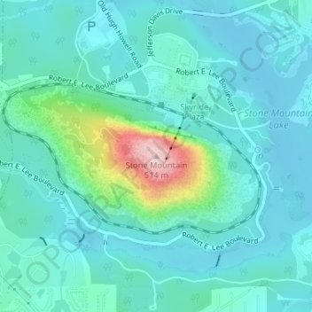
名称:Stone Mountain地形图、海拔、地势。
地点:Stone Mountain, DeKalb County, Georgia, 30087, United States (33.80617 -84.14580 33.80627 -84.14570)
平均海拔:299 米
最低海拔:254 米
最高海拔:513 米
其他地形图
点击地图以查看其地形、其海拔和其地势。
Tucker
United States > Georgia > DeKalb County
Tucker, at 1,117 feet (340 m) above sea level, is the highest point of elevation on the railroad line between Atlanta and Richmond, Virginia.
平均海拔:307 米
Tucker
United States > Georgia > DeKalb County
Tucker, at 1,117 feet (340 m) feet above sea level, is the highest point of elevation on the railroad line between Atlanta and Richmond, Virginia.
平均海拔:307 米
Tucker
United States > Georgia > DeKalb County > Tucker
Tucker, at 1,117 feet (340 m) feet above sea level, is the highest point of elevation on the railroad line between Atlanta and Richmond, Virginia.
平均海拔:317 米