Basel地形图
点击地图以显示海拔。
关于这张地图
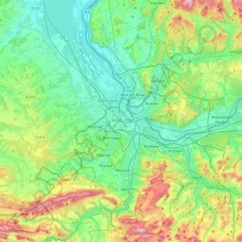
名称:Basel地形图、海拔、地势。
地点:Basel, Basel-City, 4001, Switzerland (47.39811 7.42783 47.71811 7.74783)
平均海拔:404 米
最低海拔:216 米
最高海拔:931 米
其他地形图
点击地图以查看其地形、其海拔和其地势。

点击地图以显示海拔。
名称:Basel地形图、海拔、地势。
地点:Basel, Basel-City, 4001, Switzerland (47.39811 7.42783 47.71811 7.74783)
平均海拔:404 米
最低海拔:216 米
最高海拔:931 米
点击地图以查看其地形、其海拔和其地势。