
Wexford地形图
点击地图以显示海拔。
关于这张地图
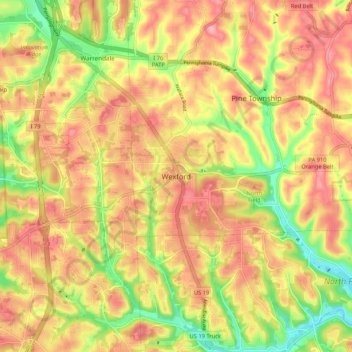
名称:Wexford地形图、海拔、地势。
平均海拔:361 米
最低海拔:292 米
最高海拔:410 米
其他地形图
点击地图以查看其地形、其海拔和其地势。
Pittsburgh
United States > Pennsylvania > Allegheny County
Pittsburgh, located in Allegheny County, Pennsylvania, is characterized by its distinct and varied topography, shaped by the confluence of the Allegheny, Monongahela, and Ohio rivers. The city itself is situated at an average elevation of approximately 764 feet (233 meters) above sea level, with the terrain…
平均海拔:303 米
Pittsburgh
United States > Pennsylvania > Allegheny County
The warmest month of the year in Pittsburgh is July, with a 24-hour average of 73.2 °F (22.9 °C). Conditions are often humid, and combined with highs reaching 90 °F (32 °C) on an average 9.5 days a year, a considerable heat index arises. The coolest month is January, when the 24-hour average is 28.8 °F…
平均海拔:303 米
Bethel Park
United States > Pennsylvania > Allegheny County
According to the U.S. Census Bureau, the borough had a total area of 11.7 square miles (30 km2), all land. Its average elevation is 1,197 feet (365 m) above sea level. Bethel Park lies at the margin between the Pittsburgh Low Plateau and Waynesburg Hills Sections of the Allegheny Plateau physiographic…
平均海拔:347 米
Pittsburgh
United States > Pennsylvania > Allegheny County
The warmest month of the year in Pittsburgh is July, with a 24-hour average of 73.2 °F (22.9 °C). Conditions are often humid, and combined with highs reaching 90 °F (32 °C) on an average 9.5 days a year, a considerable heat index arises. The coolest month is January, when the 24-hour average is 28.8 °F…
平均海拔:303 米
Bridgeville
United States > Pennsylvania > Allegheny County
Even more significant to the development of Bridgeville was the advent of commercial coal mining. The Pittsburgh Coal Seam was perhaps the most valuable mineral resource in North America in the late 1800s. Ranging from forty inches to six feet thick it was located at an elevation that produced outcroppings on…
平均海拔:275 米
Moon Township
United States > Pennsylvania > Allegheny County
During the Cold War, Moon Township was the location of Nike Site PI-71, which was a battery of Nike Ajax and/or Nike Hercules surface-to-air missiles, used by US armed forces for high – and medium-altitude air defense. The former missile site is now a nature preserve.
平均海拔:316 米
Reserve Township
United States > Pennsylvania > Allegheny County
The land that became Reserve Township was part of a 3,000-acre (1,200 ha) tract that the Pennsylvania General Assembly reserved in 1783 for state use, from which the township later took its name. Surveyed by Alexander McClean in 1785, the tract extended at least one mile inland from the Allegheny and Ohio…
平均海拔:312 米
Carnegie
United States > Pennsylvania > Allegheny County
According to the United States Census Bureau, the borough has a total area of 1.6 square miles (4.1 km2), all land. Its average elevation is 833 ft (254 m) above sea level.
平均海拔:275 米
Braddock
United States > Pennsylvania > Allegheny County
According to the U.S. Census Bureau, the borough has a total area of 0.6 square miles (1.6 km2), 0.6 square miles (1.6 km2) of which is land and 0.1 square miles (0.26 km2) (13.85%) of which is water. Its average elevation is 764 ft (233 m) above sea level.
平均海拔:275 米
Braddock Hills
United States > Pennsylvania > Allegheny County
According to the United States Census Bureau, the borough has a total area of 1.0 square mile (2.6 km2), all land. Its average elevation is 1,102 ft (336 m) above sea level.
平均海拔:322 米
Carnegie
United States > Pennsylvania > Allegheny County
According to the United States Census Bureau, the borough has a total area of 1.6 square miles (4.1 km2), all land. Its average elevation is 833 ft (254 m) above sea level.
平均海拔:275 米
Moon Township
United States > Pennsylvania > Allegheny County
During the Cold War, Moon Township was the location of Nike Site PI-71, which was a battery of Nike Ajax and/or Nike Hercules surface-to-air missiles, used by US armed forces for high – and medium-altitude air defense. The former missile site is now a nature preserve.
平均海拔:316 米
Bethel Park
United States > Pennsylvania > Allegheny County
According to the U.S. Census Bureau, the borough had a total area of 11.7 square miles (30 km2), all of it land. Its average elevation is 1,197 feet (365 m) above sea level. Bethel Park lies at the margin between the Pittsburgh Low Plateau and Waynesburg Hills Sections of the Allegheny Plateau physiographic…
平均海拔:347 米
South Park Township
United States > Pennsylvania > Allegheny County
The township is on the Allegheny Plateau, near where the Allegheny River from the northeast and Monongahela River from the southeast join to form the Ohio River in Pittsburgh. South Park township's topography is quite hilly. The hilltops are somewhat "carved" out by the streams in the area.
平均海拔:332 米
Castle Shannon
United States > Pennsylvania > Allegheny County
According to the United States Census Bureau, the borough has a total area of 1.6 square miles (4.1 km2), all land. Its average elevation is 1,040 feet (320 m) above sea level.
平均海拔:354 米
South Fayette Township
United States > Pennsylvania > Allegheny County
According to the United States Census Bureau, the township has a total area of 20.4 square miles (53 km2), of which 20.95 square miles (54.3 km2) is land and 0.05% is water. The topography is mostly wooded with small hills and floodplains on four streams. It is located 14 miles (23 km) southwest of Pittsburgh.
平均海拔:328 米
Aleppo Township
United States > Pennsylvania > Allegheny County
According to the United States Census Bureau, the township has a total area of 1.8 square miles (4.7 km2), all land. Its average elevation is 1,112 feet (339 m) above sea level.
平均海拔:303 米
Pittsburgh
United States > Pennsylvania > Allegheny County
The warmest month of the year in Pittsburgh is July, with a 24-hour average of 73.2 °F (22.9 °C). Conditions are often humid, and combined with highs reaching 90 °F (32 °C) on an average 9.5 days a year, a considerable heat index arises. The coolest month is January, when the 24-hour average is 28.8 °F…
平均海拔:303 米
Carnegie
United States > Pennsylvania > Allegheny County
According to the United States Census Bureau, the borough has a total area of 1.6 square miles (4.1 km2), all land. Its average elevation is 833 ft (254 m) above sea level.
平均海拔:275 米
Pittsburgh
United States > Pennsylvania > Allegheny County
The warmest month of the year in Pittsburgh is July, with a 24-hour average of 73.2 °F (22.9 °C). Conditions are often humid, and combined with highs reaching 90 °F (32 °C) on an average 9.5 days a year, a considerable heat index arises. The coolest month is January, when the 24-hour average is 28.8 °F…
平均海拔:303 米