
Twin Lakes地形图
点击地图以显示海拔。
关于这张地图
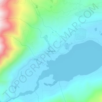
名称:Twin Lakes地形图、海拔、地势。
地点:Twin Lakes, Lake County, Colorado, 81251, United States (39.06277 -106.40197 39.10277 -106.36197)
平均海拔:2,953 米
最低海拔:2,804 米
最高海拔:3,609 米
其他地形图
点击地图以查看其地形、其海拔和其地势。
Leadville
United States > Colorado > Lake County
The City of Leadville is a statutory city that is the county seat, the most populous community, and the only incorporated municipality in Lake County, Colorado, United States. The city population was 2,602 at the 2010 census and an estimated 2,762 in 2018. It is situated at an elevation of 10,152 feet (3,094…
平均海拔:3,107 米
Mount Massive Wilderness
United States > Colorado > Lake County
The Mount Massive Wilderness is a federally designated wilderness area in the Sawatch Range, located in the U.S. state of Colorado. It is operated jointly by the United States Forest Service and the Fish and Wildlife Service as part of the San Isabel National Forest and the Leadville National Fish Hatchery. It…
平均海拔:3,432 米
Leadville
United States > Colorado > Lake County
The City of Leadville is a statutory city that is the county seat, the most populous community, and the only incorporated municipality in Lake County, Colorado, United States. The city population was 2,602 at the 2010 census and an estimated 2,762 in 2018. It is situated at an elevation of 10,152 feet (3,094…
平均海拔:3,107 米