
Atascocita地形图
点击地图以显示海拔。
关于这张地图
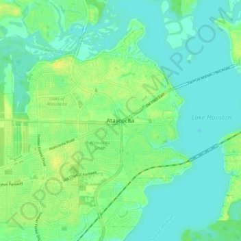
名称:Atascocita地形图、海拔、地势。
地点:Atascocita, Harris County, Texas, 77346, United States (29.95901 -95.20201 30.03901 -95.12201)
平均海拔:19 米
最低海拔:11 米
最高海拔:33 米
其他地形图
点击地图以查看其地形、其海拔和其地势。
Houston
United States > Texas > Harris County
Houston is characterized by its predominantly flat topography, sitting at an average elevation of approximately 59 feet (18 meters) above sea level. The city is situated on the Gulf Coastal Plain, which is dissected by a network of bayous that contribute to the region's drainage. This terrain was once covered…
平均海拔:25 米
Houston
United States > Texas > Harris County
Much of the city was built on forested land, marshes, or swamps, and all are still visible in surrounding areas. Flat terrain and extensive greenfield development have combined to worsen flooding. Downtown stands about 50 feet (15 m) above sea level, and the highest point in far northwest Houston is about 150…
平均海拔:25 米
Tomball
United States > Texas > Harris County
Settlement began in the Tomball area in the early 19th century, where settlers found an open, fertile land that received adequate rainfall—perfect conditions for farming and raising cattle. It was on a land granted in 1838 to William Hurd's heirs. In 1906 the area began to boom. Railroad line engineers often…
平均海拔:52 米
Houston
United States > Texas > Harris County
Much of the city was built on forested land, marshes, or swamps, and all are still visible in surrounding areas. Flat terrain and extensive greenfield development have combined to worsen flooding. Downtown stands about 50 feet (15 m) above sea level, and the highest point in far northwest Houston is about 150…
平均海拔:25 米
Houston
United States > Texas > Harris County
Houston is characterized by its predominantly flat topography, sitting at an average elevation of approximately 59 feet (18 meters) above sea level. The city is situated on the Gulf Coastal Plain, which is dissected by a network of bayous that contribute to the region's drainage. This terrain was once covered…
平均海拔:25 米
Houston
United States > Texas > Harris County
Houston is characterized by its predominantly flat topography, sitting at an average elevation of approximately 59 feet (18 meters) above sea level. The city is situated on the Gulf Coastal Plain, which is dissected by a network of bayous that contribute to the region's drainage. This terrain was once covered…
平均海拔:25 米
Buffalo Bayou
United States > Texas > Harris County
The Buffalo Bayou watershed is central to the drainage of Houston and Harris County. Lying over relatively impervious soils and very flat topography, the bayou has extensive natural floodplains, as do most Gulf coastal rivers and streams. Urbanization of the watershed has placed thousands of people in…
平均海拔:24 米
Houston
United States > Texas > Harris County
Houston is characterized by its predominantly flat topography, sitting at an average elevation of approximately 59 feet (18 meters) above sea level. The city is situated on the Gulf Coastal Plain, which is dissected by a network of bayous that contribute to the region's drainage. This terrain was once covered…
平均海拔:25 米
Tomball
United States > Texas > Harris County
Settlement began in the Tomball area in the early 19th century, where settlers found an open, fertile land that received adequate rainfall—perfect conditions for farming and raising cattle. It was on a land granted in 1838 to William Hurd's heirs. In 1906 the area began to boom. Railroad line engineers often…
平均海拔:52 米
Houston
United States > Texas > Harris County
Houston is characterized by its predominantly flat topography, sitting at an average elevation of approximately 59 feet (18 meters) above sea level. The city is situated on the Gulf Coastal Plain, which is dissected by a network of bayous that contribute to the region's drainage. This terrain was once covered…
平均海拔:25 米