
Hockai地形图
点击地图以显示海拔。
关于这张地图
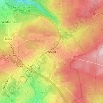
名称:Hockai地形图、海拔、地势。
地点:Hockai, Verviers, Liège, Wallonia, Belgium (50.46199 5.96636 50.50199 6.00636)
平均海拔:532 米
最低海拔:407 米
最高海拔:616 米
其他地形图
点击地图以查看其地形、其海拔和其地势。
Spa
Spa has an oceanic climate that is made more continental by its higher elevation and inland position compared to other Belgian climates at lower level or closer to the sea. Spa has a relatively high precipitation year round, with tricky weather something that the Spa-Francorchamps race track is known for. The…
平均海拔:402 米
Eupen
Eupen has a cool oceanic climate with some continental influences due to it being elevated in comparison to most of Belgium. Eupen is also wetter and cloudier than Liège in the valley to the west, as a result of orographic lift due to the elevation change. As a result of this along with frequent winter…
平均海拔:368 米
Spa
Spa has an oceanic climate that is made more continental by its higher elevation and inland position compared to other Belgian climates at lower level or closer to the sea. Spa has a relatively high precipitation year-round, with tricky weather something that the Spa-Francorchamps race track is known for. The…
平均海拔:402 米
Eupen
Eupen has a cool oceanic climate with some continental influences due to it being elevated in comparison to most of Belgium. Eupen is also wetter and cloudier than Liège in the valley to the west, as a result of orographic lift due to the elevation change. As a result of this along with frequent winter…
平均海拔:368 米
Malmedy
Malmedy has an oceanic climate with continental influences due to its inland position and higher elevation. Winter can see ice days, strong air frosts and snowfall. Malmedy's high precipitation is commonly affecting the nearby Spa-Francorchamps race track, known for its treacherous weather conditions.
平均海拔:489 米
Spa
Spa has an oceanic climate that is made more continental by its higher elevation and inland position compared to other Belgian climates at lower level or closer to the sea. Spa has a relatively high precipitation year round, with tricky weather something that the Spa-Francorchamps race track is known for. The…
平均海拔:402 米
Stavelot
Stavelot has an oceanic climate influenced by its high elevation and inland position towards a more continental type by Belgian standards. Being located at a lower elevation than neighbouring village Malmedy at the other end of the original layout of the Spa-Francorchamps race track, Stavelot is slightly…
平均海拔:431 米
Malmedy
Malmedy has an oceanic climate with continental influences due to its inland position and higher elevation. Winter can see ice days, strong air frosts and snowfall. Malmedy's high precipitation is commonly affecting the nearby Spa-Francorchamps race track, known for its treacherous weather conditions.
平均海拔:489 米
Eupen
Eupen has a cool oceanic climate with some continental influences due to it being elevated in comparison to most of Belgium. Eupen is also wetter and cloudier than Liège in the valley to the west, as a result of orographic lift due to the elevation change. As a result of this along with frequent winter…
平均海拔:368 米