
Hempstead地形图
点击地图以显示海拔。
关于这张地图
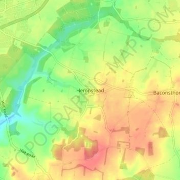
名称:Hempstead地形图、海拔、地势。
平均海拔:68 米
最低海拔:35 米
最高海拔:98 米
其他地形图
点击地图以查看其地形、其海拔和其地势。
Knapton
United Kingdom > England > Norfolk > North Norfolk
The present church dates from mainly the 14th century. The tower is set into the north west corner of the building. The porch is on the southern elevation. Atop of the church there is a weathervane designed by J.S. Cotman an artist famed as a member of the Norwich school. Inside there is a 13th-century font on…
平均海拔:29 米