
Grays地形图
点击地图以显示海拔。
关于这张地图
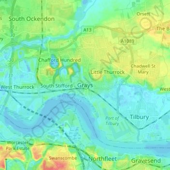
名称:Grays地形图、海拔、地势。
地点:Grays, Thurrock, Essex, England, RM17 6NP, United Kingdom (51.43809 0.28331 51.51809 0.36331)
平均海拔:14 米
最低海拔:-5 米
最高海拔:54 米
其他地形图
点击地图以查看其地形、其海拔和其地势。
Canvey Island
United Kingdom > England > Essex > Castle Point > Canvey
In 1607 the Elizabethan antiquarian William Camden noted in his work Britannia (a topographical and historical survey of all of Great Britain and Ireland) that Canvey Island (which he called Island Convennon) was documented in the 2nd century by the Alexandrian geographer Ptolemy. In his work Geographia,…
平均海拔:10 米
River Crouch
United Kingdom > England > Essex
The Crouch rises in 'The Wilderness' on the Burstead Golf course at Little Burstead. The Wilderness consists of several small ponds surrounded by a tiny area of ancient woodland. The ponds date from around 1250, when they were used for the farming of fish for Stockwell Hall, and also served as a defensive moat…
平均海拔:20 米
Epping Forest
United Kingdom > England > Essex > Epping Forest > Debden Green
It lies on a ridge between the valleys of the rivers Lea and Roding. It contains areas of woodland, grassland, heath, streams, bogs and ponds, and its elevation and thin gravelly soil (the result of glaciation) historically made it less suitable for agriculture. The Forest was historically managed as a common;…
平均海拔:44 米
Little Easton
United Kingdom > England > Essex > Uttlesford > Little Easton
Living in the parish were Lord and Lady Brooke, the later Earl and Countess of Warwick, at Easton Lodge, who were also resident at Berwick House in the Stable Yard of St James's Palace, London, and in 1902, after elevation to title, Warwick Castle. Parish occupations in 1882 included three farmers, one of whom…
平均海拔:88 米