
Islas Malvinas地形图
点击地图以显示海拔。
关于这张地图
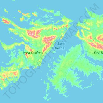
名称:Islas Malvinas地形图、海拔、地势。
地点:Islas Malvinas, Falkland Islands (-52.42360 -60.28467 -51.14360 -59.00467)
平均海拔:34 米
最低海拔:-1 米
最高海拔:698 米
其他地形图
点击地图以查看其地形、其海拔和其地势。
Beaver Island
Other islands in the group include Staats Island, with an area of 500 hectares (1,200 acres); Tea Island, which covers 310 hectares (770 acres); Governor Island, which covers 220 hectares (540 acres); Split Island, with an area of 70 hectares (170 acres) and a few smaller islands. Though the smaller islands in…
平均海拔:24 米