
Kensington Gardens地形图
互动地图
点击地图以显示海拔。
关于这张地图
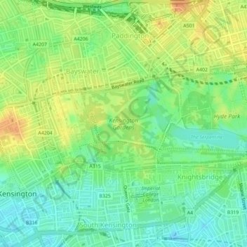
名称:Kensington Gardens地形图、海拔、地势。
平均海拔:25 米
最低海拔:8 米
最高海拔:44 米
其他地形图
点击地图以查看其地形、其海拔和其地势。
London Borough of Tower Hamlets
London Borough of Tower Hamlets, 伦敦, Greater London, 英格兰 / 英格蘭, 英国 / 英國
平均海拔:9 米
East Sheen Common
East Sheen Common, North Sheen, 泰晤士河畔列治文區, 伦敦, Greater London, 英格兰 / 英格蘭, 英国 / 英國
平均海拔:20 米
Holland Park
Holland Park, Notting Hill, Royal Borough of Kensington and Chelsea, 伦敦, Greater London, 英格兰 / 英格蘭, 英国 / 英國
平均海拔:17 米