
Jowai地形图
点击地图以显示海拔。
Jowai
Jowai (IPA: ʤəʊˈwaɪ) is the headquarters of the West Jaintia Hills district of the state of Meghalaya, India, and is home to the Pnar, a sub-tribe of the Khasi people. It is located on a plateau surrounded on three sides by the Myntdu river bordering Bangladesh to the south (about 50 km from the Indo-Bangladesh border). Due to its high altitude of 1365 m above sea level, Jowai experiences warm summers with cool to chilly winters.
关于这张地图
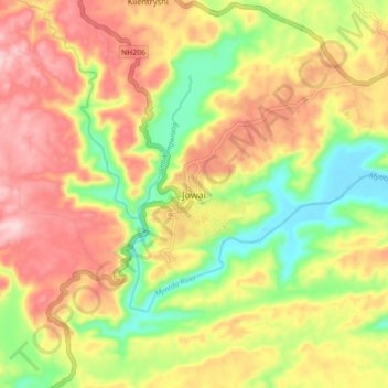
名称:Jowai地形图、海拔、地势。
平均海拔:1,332 米
最低海拔:1,211 米
最高海拔:1,445 米