
San Agustin地形图
点击地图以显示海拔。
关于这张地图
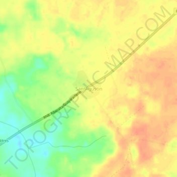
名称:San Agustin地形图、海拔、地势。
地点:San Agustin, Guayaramerín, Beni, Bolivia (-10.97238 -65.51197 -10.93238 -65.47197)
平均海拔:142 米
最低海拔:115 米
最高海拔:158 米
其他地形图
点击地图以查看其地形、其海拔和其地势。
Cachuela Esperanza
Bolivia > Beni > Guayaramerín
Cachuela Esperanza ("rapids of hope") is situated on the right bank at the rapids of Beni River, 30 km before its confluence with Mamoré River which both form the Madeira River there. The village is only accessible on dirt roads and is located at an elevation of 134 m.
平均海拔:121 米