
Phalodi地形图
点击地图以显示海拔。
关于这张地图
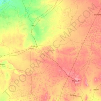
名称:Phalodi地形图、海拔、地势。
地点:Phalodi, Rajasthan, India (26.53736 71.80701 27.62025 73.13854)
平均海拔:261 米
最低海拔:151 米
最高海拔:415 米
其他地形图
点击地图以查看其地形、其海拔和其地势。
Udaipur
India > Rajasthan > Girwa Tehsil
Udaipur is located at 24°31′30″N 73°40′38″E / 24.525049°N 73.677116°E / 24.525049; 73.677116. The city covers an area of 64 km2 (25 sq mi) and lies at an altitude of 598.00 m (1,962 ft) above sea level. It is located in the southern region of Rajasthan, near the Gujarat border. The city…
平均海拔:656 米
Nainwa
India > Rajasthan > Nainwa Tehsil
Nainwan is located at 25°46′N 75°51′E / 25.77°N 75.85°E / 25.77; 75.85. It has an average elevation of 291 metres (954 feet).The town is situated at a distance of 95 km from Kota, 165 km from Jaipur, and 65 km from Bundi. There is no rail network in the town. The nearest railway station is in…
平均海拔:298 米
Kumher
India > Rajasthan > Kumher Tehsil
Kumher is located at 27°19′N 77°22′E / 27.32°N 77.37°E / 27.32; 77.37. It has an average elevation of 176 metres (577 feet). Kumher is also the birthplace of the illustrious Arya Samaji Vedic and Ayurvedic scholar, Pt. Satyendranath Vaidya (1902–1982).
平均海拔:179 米
Sadri
India > Rajasthan > Desuri Tehsil
Sadri is located at 25°11′N 73°26′E / 25.18°N 73.43°E / 25.18; 73.43. It has an average elevation of 502 meters.
平均海拔:362 米
Makrana
India > Rajasthan > Makrana Tehsil
Makrana is located at 27°03′N 74°43′E / 27.05°N 74.72°E / 27.05; 74.72, and has an average elevation of 408 metres (1,339 ft). It lies in the middle of the Aravalli Range, and these mountains are the source of its fame as a marble producer.
平均海拔:427 米
Mount Abu
India > Rajasthan > Abu Road Tehsil
Mount Abu town, the only hill station in Rajasthan, is at an elevation of 1,220 m (4,003 ft). It has been a popular retreat from the heat of Rajasthan and neighboring Gujarat for centuries.
平均海拔:914 米