
Iriga地形图
点击地图以显示海拔。
关于这张地图
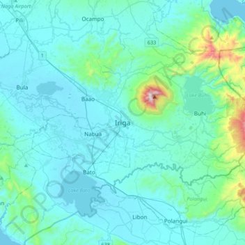
名称:Iriga地形图、海拔、地势。
地点:Iriga, Camarines Sur, Bicol Region, 4431, Philippines (13.26226 123.25294 13.58226 123.57294)
平均海拔:115 米
最低海拔:0 米
最高海拔:1,132 米
其他地形图
点击地图以查看其地形、其海拔和其地势。
Mount Isarog
Philippines > Camarines Sur > Consocep
Mount Isarog is an active stratovolcano located in the province of Camarines Sur, Philippines, on the island of Luzon. The mountain has active fumaroles and hot springs. It has an elevation of 2,011.6 m (6,600 ft) above mean sea level.
平均海拔:671 米
Nabua
Nabua has about 8,803.0600 hectares or 99.42% very low elevation or less than 100 meters elevation and remaining 51.3593 hectares or 0.58% of low elevation or between 100 and 300 meters elevation. Its slope covers about 7,927.3616 hectares or 89.53% which are level to nearly level (0-3%) while the remaining…
平均海拔:27 米