
Mount Adams地形图
点击地图以显示海拔。
Mount Adams
Adams is one of the long-lived volcanoes in the Cascade Range, with minor activity beginning 900,000 years ago and major cone building activity beginning 520,000 years ago. The whole mountain has been completely eroded by glaciers to an elevation of 8,200 feet (2,500 m) twice during its lifetime. The current cone was built during the most recent major eruptive period 40,000–10,000 years ago.
关于这张地图
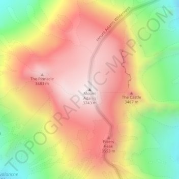
名称:Mount Adams地形图、海拔、地势。
地点:Mount Adams, Yakima County, Washington, United States (46.20235 -121.49101 46.20245 -121.49091)
平均海拔:3,235 米
最低海拔:2,608 米
最高海拔:3,741 米
其他地形图
点击地图以查看其地形、其海拔和其地势。