
Ambuclao地形图
点击地图以显示海拔。
关于这张地图
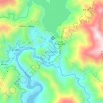
名称:Ambuclao地形图、海拔、地势。
平均海拔:841 米
最低海拔:586 米
最高海拔:1,323 米
其他地形图
点击地图以查看其地形、其海拔和其地势。
La Trinidad
The terrain is generally mountainous with springs, rivers and creeks. The town has a valley which encompasses several barangays. The valley floor elevation is at 1,300 metres (4,300 ft) above sea level. Elevation ranges from 500 to 1,700 metres (1,600 to 5,600 ft) above sea level.
平均海拔:1,123 米
Ambuklao Dam
Philippines > Benguet > Ambuclao > Ambangol
SNAP-Benguet began a massive rehabilitation project that restored Ambuklao to operating status and increased its capacity from 75 MW to 105 MW. The project required the construction of a new intake, headrace and penstock, elevation of tailrace tunnel outlet, de-silting of tailrace tunnel and replacement of…
平均海拔:808 米
La Trinidad
The terrain is generally mountainous with springs, rivers and creeks. The town has a valley which encompasses several barangays. The valley floor elevation is at 1,300 metres (4,300 ft) above sea level. Elevation ranges from 500 to 1,700 metres (1,600 to 5,600 ft) above sea level.
平均海拔:1,123 米