
卡尔加里地形图
互动地图
点击地图以显示海拔。
关于这张地图
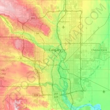
名称:卡尔加里地形图、海拔、地势。
地点:卡尔加里, 艾伯塔省, 加拿大 (50.84253 -114.31576 51.21250 -113.86000)
平均海拔:1,106 米
最低海拔:957 米
最高海拔:1,349 米
卡加利(英語:Calgary,發音: /ˈkælɡəri/),中国大陆译为卡尔加里,又譯卡加立、卡技利,簡稱卡城,是位於加拿大亞伯達省南部洛磯山脈山麓的城市,亦是該省最大城市。該市面积789.9平方公里,海拔约1048米。
其他地形图
点击地图以查看其地形、其海拔和其地势。
Cochrane Lake
加拿大 > 艾伯塔省 > Rocky View County
Cochrane Lake, Rocky View County, 艾伯塔省, T4C 0A8, 加拿大
平均海拔:1,291 米
Lake Louise
加拿大 > 艾伯塔省 > Improvement District No. 9
Lake Louise, Improvement District No. 9, 艾伯塔省, 加拿大
平均海拔:1,617 米
Hairy Hill
加拿大 > 艾伯塔省 > County of Two Hills > Hairy Hill
Hairy Hill, County of Two Hills, 艾伯塔省, 加拿大
平均海拔:619 米
Wainwright
加拿大 > 艾伯塔省 > Town of Wainwright > Wainwright
Wainwright, Town of Wainwright, 艾伯塔省, T9W 1C5, 加拿大
平均海拔:685 米
Elk Point
加拿大 > 艾伯塔省 > Town of Elk Point > Elk Point
Elk Point, Town of Elk Point, 艾伯塔省, T0A 0B9, 加拿大
平均海拔:618 米
Plamondon
加拿大 > 艾伯塔省 > Lac La Biche County > Plamondon
Plamondon, Lac La Biche County, 艾伯塔省, T0A 2T0, 加拿大
平均海拔:562 米
Village of Alliance
加拿大 > 艾伯塔省 > Village of Alliance
Village of Alliance, 艾伯塔省, T0B 0A0, 加拿大
平均海拔:709 米
County of Grande Prairie
加拿大 > 艾伯塔省 > County of Grande Prairie
County of Grande Prairie, 艾伯塔省, 加拿大
平均海拔:773 米
Burdett
加拿大 > 艾伯塔省 > County of Forty Mile > Burdett
Burdett, County of Forty Mile, 艾伯塔省, T0K 0J0, 加拿大
平均海拔:788 米
Grassy Lake
加拿大 > 艾伯塔省 > Municipal District of Taber > Grassy Lake
Grassy Lake, Municipal District of Taber, 艾伯塔省, T0K 0Z0, 加拿大
平均海拔:807 米
Vegreville
加拿大 > 艾伯塔省 > Town of Vegreville > Vegreville
Vegreville, Town of Vegreville, 艾伯塔省, 加拿大
平均海拔:638 米