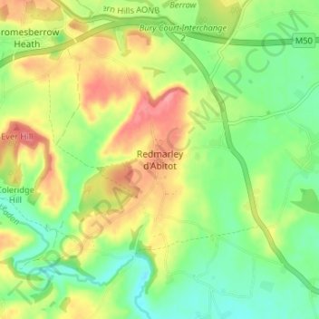
点击地图以显示海拔。
名称:Redmarley d'Abitot地形图、海拔、地势。
地点:Redmarley d'Abitot, Forest of Dean, Gloucestershire, England, GL19 3JP, United Kingdom (51.96004 -2.38154 52.00004 -2.34154)
平均海拔:50 米
最低海拔:15 米
最高海拔:95 米
点击地图以查看其地形、其海拔和其地势。
United Kingdom > England > Gloucestershire > Forest of Dean > Newland
平均海拔:151 米
United Kingdom > England > Gloucestershire > Forest of Dean
平均海拔:178 米
平均海拔:26 米
平均海拔:210 米
平均海拔:32 米
平均海拔:148 米
平均海拔:130 米
平均海拔:77 米
平均海拔:49 米
平均海拔:173 米
平均海拔:54 米
平均海拔:147 米
United Kingdom > England > Gloucestershire > Forest of Dean > Lydney > Naas
平均海拔:7 米
平均海拔:175 米
United Kingdom > England > Gloucestershire > Forest of Dean > Coleford
平均海拔:193 米
United Kingdom > England > Gloucestershire > Forest of Dean > Mitcheldean
平均海拔:157 米