
Palāmu地形图
点击地图以显示海拔。
关于这张地图
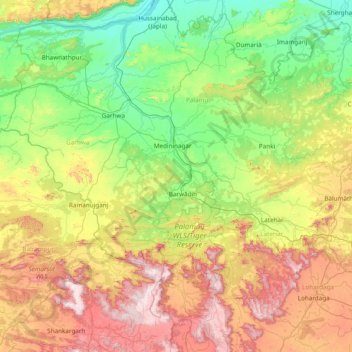
名称:Palāmu地形图、海拔、地势。
地点:Palāmu, Palamu District, Jharkhand, India (23.21667 83.38333 24.61667 84.78333)
平均海拔:448 米
最低海拔:120 米
最高海拔:1,217 米
其他地形图
点击地图以查看其地形、其海拔和其地势。
Giridih
Giridih is located at 24°11′N 86°18′E / 24.18°N 86.3°E / 24.18; 86.3. It has an average elevation of 289 metres (948 ft). Śrī Sammed Shikharji also known as the Parasnath Hills, located in Giridih district is the highest mountain peak in Jharkhand. It is a conical granite peak located 4,477…
平均海拔:292 米