Åreskutan地形图
点击地图以显示海拔。
关于这张地图
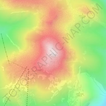
名称:Åreskutan地形图、海拔、地势。
地点:Åreskutan, Åre kommun, Jämtland County, 837 52, Sweden (63.43134 13.09323 63.43144 13.09333)
平均海拔:1,120 米
最低海拔:784 米
最高海拔:1,414 米
其他地形图
点击地图以查看其地形、其海拔和其地势。

点击地图以显示海拔。
名称:Åreskutan地形图、海拔、地势。
地点:Åreskutan, Åre kommun, Jämtland County, 837 52, Sweden (63.43134 13.09323 63.43144 13.09333)
平均海拔:1,120 米
最低海拔:784 米
最高海拔:1,414 米
点击地图以查看其地形、其海拔和其地势。