
Günzenhausen地形图
点击地图以显示海拔。
关于这张地图
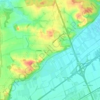
名称:Günzenhausen地形图、海拔、地势。
平均海拔:477 米
最低海拔:454 米
最高海拔:521 米
其他地形图
点击地图以查看其地形、其海拔和其地势。
Moosburg
Germany > Bavaria > Landkreis Freising
The oldest town between Regensburg and Italy, it lies on the river Isar at an altitude of 421 m (1381 ft). It has 20,237 inhabitants (2022) and covers an area of 44 km2. It is easily reached by the A 92 autobahn and regional trains on the Munich–Regensburg line. Furthermore, it takes just 20 minutes to get…
平均海拔:428 米