
Apaña地形图
点击地图以显示海拔。
关于这张地图
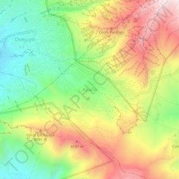
名称:Apaña地形图、海拔、地势。
地点:Apaña, Palca, Pedro Domingo Murillo, La Paz, Bolivia (-16.56680 -68.04368 -16.52680 -68.00368)
平均海拔:3,924 米
最低海拔:3,574 米
最高海拔:4,332 米
其他地形图
点击地图以查看其地形、其海拔和其地势。
La Paz
Bolivia > La Paz > Pedro Domingo Murillo
Located in west-central Bolivia 68 km (42 mi) southeast of Lake Titicaca, La Paz is set in a canyon created by the Choqueyapu River. It is in a bowl-like depression, part of the Amazon basin, surrounded by the high mountains of the Altiplano. Overlooking the city is the triple-peaked Illimani. Its peaks are…
平均海拔:3,544 米
La Paz
Bolivia > La Paz > Pedro Domingo Murillo
The city, in west-central Bolivia 68 km (42 mi) southeast of Lake Titicaca, is set in a canyon created by the Choqueyapu River. It is in a bowl-like depression, part of the Amazon basin, surrounded by the high mountains of the Altiplano. Overlooking the city is the towering, triple-peaked Illimani. Its peaks…
平均海拔:3,544 米
La Paz
Bolivia > La Paz > Pedro Domingo Murillo
The city, in west-central Bolivia 68 km (42 mi) southeast of Lake Titicaca, is set in a canyon created by the Choqueyapu River. It is in a bowl-like depression, part of the Amazon basin, surrounded by the high mountains of the Altiplano. Overlooking the city is the triple-peaked Illimani. Its peaks are always…
平均海拔:3,544 米
Mecapaca
Bolivia > La Paz > Pedro Domingo Murillo
Mecapaca Municipality is the second municipal section of the Pedro Domingo Murillo Province in the La Paz Department, Bolivia. Its seat is Mecapaca. It is situated 28 km from the city of La Paz, the capital of the department and the seat of government for the country, and it stands at an elevation of 2,850…
平均海拔:3,684 米
La Paz
Bolivia > La Paz > Pedro Domingo Murillo
The city, in west-central Bolivia 68 km (42 mi) southeast of Lake Titicaca, is set in a canyon created by the Choqueyapu River. It is in a bowl-like depression, part of the Amazon basin, surrounded by the high mountains of the Altiplano. Overlooking the city is the towering, triple-peaked Illimani. Its peaks…
平均海拔:3,544 米