
Laen East地形图
互动地图
点击地图以显示海拔。
关于这张地图
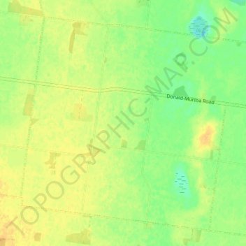
名称:Laen East地形图、海拔、地势。
地点:Laen East, Shire of Buloke, 维多利亚州, 澳大利亚 (-36.42296 142.87069 -36.37476 142.93966)
平均海拔:121 米
最低海拔:106 米
最高海拔:132 米
其他地形图
点击地图以查看其地形、其海拔和其地势。
Trentham Falls
Trentham Falls, Trentham, Shire of Hepburn, 维多利亚州, 3458, 澳大利亚
平均海拔:689 米
Dandenong District
Dandenong District, 墨爾本, City of Greater Dandenong, 维多利亚州, 澳大利亚
平均海拔:40 米