
Piñon Acres地形图
点击地图以显示海拔。
关于这张地图
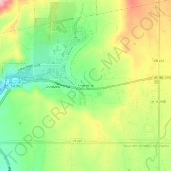
名称:Piñon Acres地形图、海拔、地势。
地点:Piñon Acres, La Plata County, Colorado, United States (37.20778 -107.83729 37.24778 -107.79729)
平均海拔:2,102 米
最低海拔:2,010 米
最高海拔:2,216 米
其他地形图
点击地图以查看其地形、其海拔和其地势。
Durango
United States > Colorado > La Plata County
Durango is set within a striking and diverse topography characterized by its elevation of 6,512 feet above sea level and its position in the Animas River Valley. The city lies at the foothills of the rugged La Plata Mountains to the west and is flanked by the San Juan Mountains to the north and east. This…
平均海拔:2,162 米
Durango
United States > Colorado > La Plata County
Durango is located at 37°16′N 107°52′W / 37.267°N 107.867°W / 37.267; -107.867 at an elevation of 6,512 ft (1,988 m). At the 2020 United States Census, the town had a total area of 10,946 acres (44.296 km2) including 1,533 acres (6.203 km2) of water.
平均海拔:2,162 米